Part Three of the Big Boat Delivery HOME From Michigan to Lake Simcoe
After departing Kincardine, we headed northward across the last half of our time on Lake Huron. To clarify, that would be the last time this time.
Another 80 miles of open water traveling brought us to our turning point at Cape Hurd. This is where Georgian Bay begins - or ends, depending on your orientation - and Lake Huron (proper) is left behind;

Video taken just before rounding 'Cape Hurd';
Video of us passing through 'Devils' Island Channel' - leaving Lake Huron and coming onto Georgian Bay and passing dangerously close to the North Channel ;-)
Upon arriving at Tobermory, we found out that there were no more empty slips available and that we would have to raft off one of the tour boats already tied to the wall. The only catch was that if said boat was to head out, we would have to untie from him, drive out into the harbour, allow him to leave, tie up to the wall ourselves and wait for him to return, upon which redoing that sequence again in reverse.
Well, my approach and docking was not the most stress free, considering the traffic, congestion and strong winds, so I asked the dock attendant is there was any chance of us NOT having to be subject to that scenario. Thing was, that after more than five hours on the water, I was looking forward to relaxing with an ice cold beer or two which meant I wasn't going to be doing any more driving that day. Fortunately, we got word that the tour boat was planing to stay put for the rest of the day and the following one, so we could look forward to some down time.

I took this clip of the Blue Heron cruse boat - one of the many - coming back into Little Tub Harbour.This 'glass bottom' boat takes passengers out to see some of the many wrecks lying on the bottom in the area, as well as a tour of Flower Pot Island;
Here's a look out of our port hind quarter. Tobermory is the only spot in the area for boaters to re-provision and has pretty much everything one would need, including a full Foodland grocery store, laundry mat, boating supplies (we picked up our Canadian bow flag here) as well as a liquor store and fuel dock.
Beyond that, there is a launch ramp and is ground zero for tour and dive boats, as well as the many private vessels that come and go and, of course, the overnighting transients, such as ourselves;

Here's a shot of Boogaboo tied up alongside the steel hulled tour/dive boat that was our companion for two days and nights. I'm glad he was tied well to the dock as we would have some really high winds the second evening we were here;

Looking north east from the town docks. I tell ya, this place is not one for the faint of heart to get into for the first time, but I guess that's part of the adventure. And it keeps the blood pumping ;-)

Here's something from this same spot, just looking around;
I went for a walk up to see the 'Chi-Cheemaun', a car and passenger ferry that runs between Tobermory and Manitoulin Island.To give you an idea of the scale of this vessel, it is capable of carrying up to 638 passengers and 143 cars. That is a big boat;
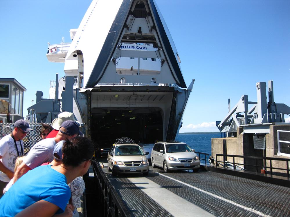
Yes, this big boat is big enough to carry a full sized tractor-trailer;
The 'Cheech';

Here's a look at one of the great lakes fishing boats in the area. This is similar to the one we encountered on Lake Huron when we came upon the unexpected fishing nets out in the middle of nowhere;

Anchor Girl looking forward to doing some shopping - and picking up that Canadian Flag for the boat;

OK, so I just had to throw in another picture of my new boat. Don't groan about it just yet - there's gonna be a few more before we are done with this thing;

Another look from the bridge. The sail boat in front of us had put up all these pennants on his mast, but I'm not sure of the significance. Any ideas?

A busy day on the water. Boats were continuously coming and going from this SUPER busy, congested port;
t
Here's another panning shot I took of the harbour from one of the finger docks. Little Tub Harbour is oriented along a mostly north/south line, affording it some protection from the prevailing north-west winds. Given the force of these winds, sometimes that protection is quite limited. The last night we were here, the winds were blowing very strong from that same north-westerly direction and the fetch was funneled down into the harbour. Fortunately for us, the brunt of the waves produced didn't get to us, but the boats on the floating finger docks in the distance were moving a solid 4' up and down. The result of that was the boats tied up to them being flung up and down along with them! There's no way that the occupants on board any of those boats would have been able to sleep that night!!
On our way. Another beautiful, sunny morning as we leave our berth and head over to the requisite fill up at the gas dock. Thankfully, the high winds from the night before have subsided - but the resulting swells on The Bay haven't;

I had to share this one with you we saw here. What do you think of the bright yellow canvas? Buddy must have got a deal on the material or something;

A parting shot of the Chi-Cheemaun as we leave Little Tub Harbour and get back onto Georgian Bay;

Here is the Big Tub Lighthouse, marking safe passage into Tobermory;

Just beyond Tobermory sits 'Flower Pot Island' with it's world renowned formations;

Here's a more close in view. We took, or at least attempted to take a number of photos of these unique formations, but the rolling waves were rocking us so much it was difficult to get a clear shot. As a result these two were the best we were able to get;

The video offers a bit of insight to the rocking and rolling we witnessed. The really cool part is that despite how close in to shore we got, the water was still over 300' deep!
On our way, cruising eastward toward or destination of Midland at 3300 RPM, doing 22 MPH (statute) in 392 feet of water!

This was the deepest I was able to record at that speed - 462.7 feet! How cool is that?!?

Today's' final photo & video clip were taken just after rounding Hope Island and passing by Beckwith Island.
As I've said a few times before, the photos and videos don't capture the size of the waves, but I must say that this leg of the trip was the roughest, as we were taking the waves on the port beam all the way from Owen Sound to this turning point;

Here's some very moving pictures from here. Note the comments from myself about the "one foot waves . ." we were going through. Anchor Girl follows that up when I loose my footing shortly afterward ;-)
-------------------------------------------------------------------------
---------------------------------------------------------------

I'd like to publicly thank my lovely wife for not only supporting me on the whole boat buying adventure, but for making this trip both a possibility and a reality.
For those of you who aren't aware, driving on the boat - any boat - in rough conditions is, ah, well, shall I say 'stressful' for Anchor Girl and there was more than one time on the trip up to this point when we found ourselves in some pretty big stuff. For me it's all part of the adventure but I was deeply aware of how uncomfortable some of the journey was and made every effort to overcome that part.
Again, thank you for your enduring help, understanding and patience.
-------------------------------------------------------------------------
---------------------------------------------------------------
Next time, we get to set the hook and anchor out for a few peaceful days and nights in Beausoeil Bay and are joined by the crew of 'Water Wings'.
:-)