|
| Back on The Bay |
Ya, ya, ya - more Georgian Bay stuff . . .
Can't help it, I love boating on The Bay :-) Nothing like dreaming, planning and looking forward to getting away for our summer boating holidays - and The Bay has been the place to dream about for the past number of years.
That said, I'm really looking forward to going back to there this summer, but work commitments might not allow for our regular three week hiatus. We might have to break things up a bit to two or more shorter holidays, including a possible run eastward on the Trent . So, the lovey Anchor Girl & I are talking about, in addition to a shorter trip to Georgian Bay, maybe doing a week or so eastward, toward Peterborough. We'll have to let time & tide decide . . .
Speaking of holidays and time off, we've been fortunate enough to spend some time down south in Florida this past year and we are already planning for spending even more time down there. Ya, like retirement - but that's a ways away. Believe it or not, but I got one or two pictures I'm going to be sharing here, along with some video of our time in Fort Lauderdale. But that's for another day.
Back to today's post. Due to the large number of pics that I'm compelled to share, I'm going to break this up to a couple or more posts & will break those up with some stuff from our new home at Lagoon City - including the long winded story of why/how we came to find ourselves there. Apparently, some of you hadn't heard the whole story. Or something like that.
The Bay. Let's go - - -
Pulling out of the Pefferlaw River. This would be one of the last times leaving here :-(
We had a BIG little stowaway while crossing Sparrow Lake;
Arriving at the top side of Swift Rapids Lock (#43);
It was nearly 5:00 by the time we got through the lock, so we decided to spend the night here;
Here's some video from this HOT day one of our holidays;
Notice that there's hardly any water flowing over the water control dam. It had been pretty dry out for the previous week or so and the runoff was minimal, resulting in little current through the system. We wouldn't have the same conditions on our return, making for a fun time at Lock #45, as we'll see later on;
End of Day 1 brought our first pretty sunset of many on this trip;
Next morning we continue on westward;
Next stop - well, more like slow to a crawl - was the Big Chute Marine Railway;
In case you missed it earlier, here's another video review of the ride over (down) the marine railway;
Leaving the bottom of Port Severn Lock where the Trent-Severn meets Georgian Bay. This was the calmest conditions we have ever seen going through here. I'll be including some video from here a bit later on, showing how dramatically things changed by the time we came back home;
All thumbs up as we are officially back on The Bay for another season's worth of memories!
When we got on to Georgian Bay, our first stop was going to be a few
nights at anchor at Beausoleil Island. Well, as we keep discovering,
boating plans tend to change rapidly when traveling. This time it was
our anchor windlass malfunctioning. When we attempted to launch the
anchor, the windlass rapidly let out all 100' of chain + rode - and then would not respond to controls any more. Fortunately, I was
able to use the built in manual winch to retrieve the anchor, but we
didn't want to spend a night on the hook without having the ability to
get up and go quickly if need be during the night, so we went to Midland Harbour
to tie up and fix the windlass.
Good thing, too, as that night
we had a strong storm blow through with lots of rain and strong winds.
So much so, that the rain was blowing through our transom door with such
force that it blew the carpet back & soaked it. Lucky? More like
protected :-)
The next day I got in touch with the windlass manufacturer & the fellow I talked to suggested the source of the problem & how to remedy it. Fortunately, it was a simple matter of disemboweling the foot controls and cleaning the contacts for the solenoid switches & voila! All operating more better, according to the professional Anchor Girl.
Listen to the sound of my voice discussing our time at Midland;
Just north of Honey Harbour the landscape & water becomes much more rough & rocky. This is approaching Monument Channel;
Gotta stay on top of them charts to stay on course in the 30,000 Islands area;
Although this spot looks wide open, there's only a narrow channel marked to get through. No problem, but we wound up catching up to these folks just at the bottom entrance to it and they weren't moving too fast at all. Just after we got behind this boat, Anchor Girl went into the cabin to make me a sandwich. When she returned to the bridge a few minutes later, we hadn't moved very far & she thought they had hit bottom & were stuck!
O'Donnell Point marker;
Sure is pretty boating up here;
Passing through the narrows at Starvation Bay means we are only a short distance to Henrys Restaurant;
See, I told ya ;-) Taking the 'Inside' passage & doing a slow cruise, this leg of the trip took us 3-1/2 hours from Midland;
Some cool looking rock formations we saw on our dingy trip over to Wreck Island;
The view from our dock at Henrys. Those islands and rock formations in the distance mark the main entrances to the anchorages of the
Massasauga Provincial Park & the Moon River basin - an adventure all to itself;
Here's a group of three photos I stitched together to form a panoramic shot;
I took many pics form this vantage point out the back of the boat, attempting to capture the beauty & essence of this spot;
Anchor Gilr walks back to the boat with a bag of ice, as we are moving on to the next spot;
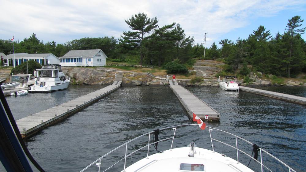
A quick parting shot of the docks. You can see they can accommodate a number of boats in a row, with the policy being that if you are at the front (closest to shore) by around 3:00, you are spending the night. There's room for up to 50 boats here. Generally, they pack 'em in for lunch & dinner, but overnight usually sees roughly 20 boats staying;
Here we are, pulling in to LeBlanc's Marina - which is right around the corner & on the same island. We needed a pump out & I learned the hard way a few years back that if there's a facility nearby that can do it, take advantage of it;
They also have a small variety store with highly inflated prices. They are also an agency LCBO outlet;
Speaking of highly inflated prices, gas here was $1.90 per litre. That works out to $8.64/gallon. Oh well, ya gotta remember that this place is on an island, many miles from where it has to be delivered from by water, and the the next closest place to get gas is at least an hour away. . . . Nobody said boating was a poor man's hobby. It only makes poor men out of us.
No, we didn't get here - this time ;-)
Next stop was Parry Sound. Good municipal marina & complete shopping facilities available, as the local Sobey's supermarket offers a free shuttle service to their store for the boaters. And there's a Canadian Tire right beside it, along with the usual assortment of stores in these bog box pods.
This is looking out from the back of the boat;
. . . And a look forward from the flybridge;
We were only here a day or two, to catch up on groceries and do some laundry, hit the beer store, etc.. We'll be returning after our next adventure.
I just wanted to share this pic of us leaving, as the big express boat to the left in this shot (a Canadian built Neptunus yacht) was equipped with a wireless remote docking apparatus. We saw the captain pulling that thing into the gas dock in town - with him maneuvering it standing on the bow. A neat show & when I yelled over to him that I considered that cheating he laughed & called it a marriage saver ;-)
Next stop was Killbear Marina;
This was our first time visiting here;
Did I promise nice sunsets or what?
Killbear has alot of bigger slips, all with 2x30 amp shorepower;
Our 2nd big bug visitor of the holidays;
Of course, Anchor Girl saw that & immediately zipped up & snapped in all the canvas. She already had one big bug on board & didn't want any more getting on;
A look out on to The Bay from the southern dock;
This is looking back from the office/chandlery store;
They have a restaurant (upstairs) and small grocery store (down) in this building. The restaurant food was quite good - they served both regular Canadian fare, as well as specialty German dishes;
Killbear Marina is in a very well protected cove, surrounded by land on three sides;
This photo shows how far out of the water the fixed docks are, a testament to how much the water level has dropped in the past 20 years;
A brave soul heads out on a windy day;
Enjoying the sunset as I prepare an evening snack for the first mate;
Mmmmmmmm, garlic bread;
Next time, we're heading north. And then south.
Stay tuned to see our encounter with a swimming dear, a very tight passage and video tours of a bunch of anchoring bays of the Moon River Basin. Heck, I might even throw in some more spectacular sunsets :-)
:-)