Showing posts with label trent severn waterway. Show all posts

Tuesday, October 4, 2022

Trent Severn Waterway Seasonal Closing for 2022

  Sadly, this coming October 10th will mark the final day of the 2022 navigation season on the lovely Trent Severn Waterway. It certainly was a challenging year for the system, with closures to to high spring waters, ongoing staffing issues at the Big Chute and finally the breakdown of the Kirkfield Lift Lock. 

 The navigation season - the time when boats are able to pass through the locks and use the facilities (washrooms, etc.) - runs from the end of May through to October each year. For a full listing of dates and hours, take a look at the Parks Canada site, here. That site will be updated sometime over the off season, usually by late winter, to give specific dates for the upcoming 2023 season.

 Hopefully, many if those issues can be rectified before the 2023 season rolls around. As we always say in the boating world - there's always next year 😀 


Sunday, September 25, 2022

Kirkfield Lift Lock Resumes 'Restricted' Operations


Lock #36 - the Kirkfield Lift Lock - of the Trent Severn Waterway (TSW) holds a unique distinction as being the 2nd highest lock of its type in the world, only surpassed by the Peterborough Lift Lock (Lock #21 of the TSW).

 Unfortunately, this lock suffered an unexpected and serious mechanical failure back on September 2/22 and had been out of service since that time. Although there's no details as to what the failure might have been, there is a short video taken by an on-land visitor during the event. The clip is less than 30 seconds in duration, but one can clearly see water rushing over the sides of the north chamber while the cruise boat 'Kawartha Voyageur' was being lifted up. 

 Here's the video from the incident;


Clearly, there was water entering that chamber when it wasn't supposed to be!

 When one passes through this lock (as well as the Peterborough Lift Lock), the chambers are made water tight by way of gates that open or close at the top and bottom sides of both chambers, so that excess water doesn't enter, nor escape from the chambers during transit. When the lift or lowering has been completed, the appropriate gate is opened to allow for the boats to exit or enter the chambers. A pretty straightforward practice that we've experienced many times over the past 15 years, all without incident. Seemed to be a very safe and well though out approach on the engineering side, but on this day something went very wrong.

Here's a video from our own up-bound passage (filmed July/22) through the lock that should illustrate how the system works. Note the gate dropping down toward the end of the video. That allows us (the boat) to exit the chamber - and relieving that watertight seal;


Now this is purely speculation on my part, but I'd hazard a guess that perhaps some debris got stuck in the upper gate which allowed the water to go through. Either that, or there was a loss of control for the mechanism that holds/locks that gate in place.
Luckily, the lock staff were able to lower the chamber so that the Kawartha Voyageur could be safely brought down and allow the passengers to exit the boat. Fortunately there were no injuries or damage to the boat immediately reported.

Here's an overhead view of the lock I took when visiting back in 2018;


Now that the Parks Canada crews have been able to do some preliminary repairs, it has been announced that 'modified lockages' will resume on September 26th. Parks Canada announced the following:
" . . .the Lift Lock has been approved to offer limited, single-chamber lockages to vessels returning to their home ports that cannot be trailered. These modified lockages will be conducted beginning on Monday, September 26, 2022, and delays experienced by boaters will vary depending on the position of the Lift Lock chambers when the boater arrives. Boaters (and pets) will be asked to disembark their vessels while the transfer is underway. Still, access to washroom facilities and shelter (in the case of inclement weather) will be made available. Vessels going up will experience a lockage time of approximately six (6) hours, while downbound vessels will experience a lockage time of approximately 30 minutes. . ."

The full article can be found HERE.

Hopefully the full repairs can be completed before the start of the 2023 navigation season. Will be nice to visit this spot again next year;

Thursday, April 23, 2015

Red Right Return - Navigation Buoys, Day Markers and More

 I'm often asked some interesting questions through my YouTube videos and, more often than not, I take a simple query and reply with half of a book. So, rather than simply leaving those interactions on YouTube, I figured I could share it with you all, here on the Blog. . .

 Here was today's question; ". . for a subscriber/boating newbie here; I noticed in your lake travels, there are these red and green buoys, to which you always pass between them .. why is this and what is their purpose?"


 The long and short of the Red & Green markers is to indicate where safe water is. As one cannot 'see' how deep a given area of a lake, river or canal might be, the buoys (floating) or day beacons (land based) indicate the edge of a safe way for navigation. Used in conjunction with marine charts (paper or digital), mariners can safely pass through an area where the water is shallower than what is otherwise encountered in a given area.

 That said, different boats need different depths to pass through a waterway without risking running aground and that's where the charts come in. The captain of even the smallest boat must be aware of how much draft their vessel draws - how deep in the water it sits - as well as other factors that might determine what a safe depth might be for navigating.

 For example, our current boat 'Boogaboo IV' draws approximately 40" of water, with an average load. Load refers to all the weight on the boat, including the boat itself, plus other considerations such as fuel, water, passengers, gear, food and yes, even beer ;-) As well, that draft (the depth of the boat in the water, not the beer on tap) will be greatly affected by sea conditions. If we were travelling though rough water, our boat could begin to pitch up and down, making the average depth of water we were travelling through vary considerably, depending if we were on the crest or bottom of each wave. So, if we were travelling through water with only 4 feet of depth and it was wavy, we could bounce up and down enough to touch bottom. And that's not a good thing! Also, if a passing boat were to throw off a large wake (it happens all the time), we could (and do) get bounced around.

 For all of the above reasons, it is imperative one knows where they are and can relate to their proximity to danger, as well as changing sea conditions. And that's where those red and green markers come in.

 So, why red and green, you ask? I'll tell you. In North America, as well as other parts of the world, we follow the Red-Right-Return system of telling us which is the safe side of a given marker. In MOST cases, heading upstream (against the current), the red marker is kept to the starboard, or right, side of the boat. When heading in the opposite direction, the opposite is true and one would then keep the green markers on their starboard side.

 Confused? Don't worry, it gets better. When going through areas such as Georgian Bay, that all goes out the window. Throw in other 'Aids To Navigation' such as yellow Cardinal Buoys, black (or red) and white Fairway Markers, Red/Green/Red OR Green/Red/Green Bifurcation Markers and (sometimes) land based Range Markers and you will soon realize that there's lots to learn about boating for the serious cruiser!

 Unfortunately, many boaters are blissfully unaware of what many of these things mean - or the meaning behind them

 I should really start a video series on how to learn these things and how they are put in to practice to help folks out. There is also something called 'The Rules Of The Road', which plainly lays out who has the right-of-way when on the water. Sadly and frustratingly, there are many, many boaters who don't have a clue what that means, or how to employ the rules to maintain safety. Here is a quick video I posted last summer after I got ticked off by someone who was in the aforementioned column of not knowing;

 I hope my long winded overview on this helps you better understand what goes on. If not, at least it may inspire to you learn a bit more. . . And now you also know why I put this off until I had a bit more free time ;-)

Friday, April 18, 2014

Summer 2013 Boat Cruise - Young's Point, Clear Lake and More!

Wow, I really gotta start doing these Blog posts sooner to the actual events ;-) It's hard to believe that this set of holiday pics are from last summer and we are going to be re-launched for the 2014 season in less than two weeks!! Oh well, it's always fun to look back on memorable times, and this is no less.

  This voyage takes us back to Young's Point and a nice evening with the owner of Islandview Resort. Despite the fact we were heading back towards home, there was still lots of fun and memories to be made :-)


Waiting to go up through the lock at Young's Point;
Up-bound through Young;s Point Lock - Lock #27 of the Trent Severn Waterway.

 Across from the lock stands this old bridge, built in 1884-1885 and is the only known surviving bridge that employed both wrought iron and steel in it's construction. It's also one of the oldest bridges along the Trent Severn Waterway. Once used for road traffic, it was long ago replaced by the Regional Road 28 bridge, a little to the west highway.
Young's Point bridge.


Our host for our stay, one Mr. Kieth. Um, as a side note, he has a good connection with a guy that does a great job of fashioning drinking glasses out of empty beer bottles. How we got all those empty beer bottles between the two of us is another story ;-)
Hey Kieth, have you seen my empties? ;-)


Another great spot to tie up for a night or two.
The docks at Islandview Resort and Marina.


Leaving Young's Point and heading northbound across Lake on a clear, sunny day;
A clear day on Clear Lake.


 Lots of pretty scenery as we approach Hell's Gate that separates Clear & Stony Lakes;
Hell's Gate on Stony Lake.


Anchor Girl still trying to get that perfect shot of St. Peter's Church - an incident that got us into trouble the first time passing through here, years before! Watch the upcoming video for all the details;


Perry The Penguin sure enjoyed his time travelling through here. Warm & sunny is right up his ally!
Perry The Penguin having fun on his first boating vacation.


St. Peter's Church - on the rock.
St. Peter's Church on Stony Lake.


VIDEO: Our cruise from Young's Point and through the very picturesque Hell's Gate on Stony Lake;


The aptly named Stony Lake offers similar cruising grounds to that of Georgian Bay, albeit only for a short distance of just a few miles.


At the far western end of Stony Lake is the bottom side of Burleigh Falls Lock (Lock #28), and our stop for the next two nights
Approaching Burleigh Falls Lock.


Next time, we are at Burleigh Falls Lock for a very stormy night!

:-)

Saturday, April 12, 2014

Summer Boat Cruise 2013 - Glorious Stay at Lakefield Lock

For the 2013 boating vacation voyage, this would be the farthest 'away' we were to go, Lakefield Lock - Lock #26 of the Trent Severn Waterway (TSW). I was hoping to travel to Peterborough, but with the shorter hours of operation and the fact that our usual time off work was cut back back by almost a third this year, so we decided this was it.

 Not that I am sad that we didn't get any farther, on the contrary, despite have ventured to all of the areas we saw on prior trips, this was like seeing much of it for the first time. That was as a result of our ability to stay at a number of the locks for days at a time. Having the built in generator on the boat sure gives us so much more freedom to go where we wish, while maintaining most of the comforts we would enjoy tied to our dock at home.

Like most of the other locks, this one provides a peaceful and secure setting to tie up for a night or two. As you can see in this shot, I turned Boogaboo to have the bow facing 'back home', right at the end of the wall. This allowed us easy egress when we decided to leave, as well as a good view downstream to all the comings and goings while the lock was operating.
Tie up wall at the Lakefield Lock.


Video: A really nice clip of our short run over to the Lock. Another peaceful, sunny day on the water - complete with a notable docking manoeuvre at the end ;-)


Our view from the back of the boat, looking towards the lock;
Pretty view.

Sunshine, and lots of green;
Lock #26 of the Trent Severn Waterway, at Lakefield, Ontario.


The lock chamber, looking downstream, of course. There are rumours (reported to us more than once) that this lock has the BIGGEST spiders of any along the TSW. Anchor Girl was thrilled to hear that the first time we passed through here ;-)
Be wary of the Spiders . . ..


Video: One of the few dinghy rides we took on this trip saw us heading back into the village to grab more food (natch) and BEER :-)


After the big workout from our dinghy ride, it was getting to be cocktail time. A favourite spot for us to enjoy a cool drink is sitting on our folding lounge chairs, propped on the swim platform, feet up on the floating dingy;
Watching the world go by . . .


Evening of the second day and the joint had filled up. It was nice to wander and talk to the other boaters, discussing the TSW issues;
A full house.


Our spot on the wall. Nice;
Looking forward to going back here.


Cool shot across the port side deck, complete with funky lens flare;
Shine a little sunshine on me :-)

Video: Before heading off, we walked over to the local grocery store for MORE food & I took this clip of the local walking trail, which passed right beside our mooring;


The ending shot form the video was taken overlooking the control dam, just ahead of the lock. I was able to also snap a neat still photo of the big Chris Craft riding by;
A view of top and bottom.


The next segment sees us heading back to Young's Point and some time with our host to catch up and swap stories.

:-)

Wednesday, April 9, 2014

Spring Thaw - Finally!

 After the worst winter in recent memory, Mother Nature has finally looked at the calendar and started the warming part of Spring. Ahhhh, that's nice :-)

 We took a drive up to the boat twice in the past week to check on things and it's so nice to see open water again! Nothing much on Lake Simcoe right now, but many rivers have begun to open up and flow again. Here's a pic I took where the Trent Severn Waterway enters Lake Simcoe, at Gamebridge;
Open water again :-)

 Not only is the snow and ice fading fast, but it was so nice to see the wild critters out again as well. On Sunday alone, we spotted deer, wild turkeys, lots of little creatures and tons of geese - although they aren't that pleasant to have around the marina. . . The most encouraging to see once again flying around and claiming their nests was the Osprey, returned from their southern wintering grounds.


 All of the above says that once again we are moving inexorably towards another great season on the water. Soon be time to head onto the Trent Severn Waterway and take it all in :-)
Swing bridge on the Trent Severn Waterway.


:-)

Sunday, April 6, 2014

Summer 2013 Boat Cruise - Islandview Resort, Young's Point

After a seven hour run from Fenelon Falls (including five locks), we find ourselves at another favourite place to stay for a couple of days, that being the Islandview Resort in Young's Point. Even though we were travelling for most of the day, it a great one to be on the water and we drove at an easy, relaxed pace for the most part.


We have spent a number of our getaways here and over the years the owner, Kieth has become a friend that we look forward to seeing each time we return.
Islandview Resort and Marina in Young's Point.

Located right along the main Small Craft Route, all the boats going through here have to pass right in front of the docks, making for some prime boat watching. Unfortunately, with the reduced hours in the navigation season, traffic was down quite a bit when we visited.
The gas dock at Islandview Resort.

The resort also has a good restaurant, complete with outside patio that overlooks the waterway.
Old Mill Restaurant patio.

Video: A look around at Islandview


Video: A quick mop down of Boogaboo before heading off to our next destination


As you saw in the video, we arrived to sunshine at Lakefield Marina, but by late afternoon the skies turned stormy.
Passing thunder clouds at Lakefield Marina.

Here me with the BBQ set up on the dock, hoping that the rain will stay off until dinner.
BBQ on the dock at Lakefield.

The very lovely Anchor Girl relaxes while waiting for dinner.
My beautiful First Mate.

Walking back from yet another food shopping trip ;-)


 The next morning we were off again, this time to the farthest east we would get on this trip - and another new place to stay. But first, one quick look at the marina on a sunny morning;
A sunny morning at Lakefield Marina.

:-)

Monday, March 31, 2014

Summer 2013 Boat Cruise - Fenelon Falls, Bobcaygeon & Buckhorn

This time we leave Fenelon Falls and head south and east to our next destination of Young's Point.

 The morning was beautifully calm when we departed.
Fenelon Falls railway swing bridge.

An easy one this morning, as we had zero wind and only one other boat to go through the lock with.
Heading towards the top side of the lock.

Video of us leaving the tie up wall and heading to and down-bound through the Fenelon Falls Lock;


After exiting the lock, we are into the picturesque Fenelon River which, in turn, took us into Sturgeon Lake. At the far east end is the village of Bobcaygeon and this marina - Centre Point Landing - is on the north shore, just before town when heading in from the east.
Center Point Landing Marina


Approaching the Bobcaygeon Lock, one sees the unmistakable 'Bigley's' store for ladies fashions with it's bright pink roof, located immediately beside the lock chamber. Bobcaygeon has the distinction of being the site of the very first lock along what was to become the Trent Severn Waterway, having the first one built way back in 1833.
Approaching the top side of Bobcaygeon Lock.

After getting a pump-out at Gordon Yacht Harbour and continuing east, we passed through Pigeon Lake, which becomes Buckhorn Lake (Upper) at a spot called Gannon Narrows.
Gannon Narrows Bridge.


At the far east end of Upper Buckhorn Lake sits the hamlet of Buckhorn and the Buckhorn Lock, which drops us down into Lower Buckhorn Lake. Phew, that's a lot of Buckhorns :-)
Exiting the bottom side of Buckhorn Lock.


These guys were occupying a nest/perch just past the lock.
One of the many Osprey nests to be seen along the Trent Severn Waterway.


Crossing Lower Buckhorn Lake we saw a number of these rental houseboats. One must be wary of these slow moving, heavy vessels, more likely than not to be piloted by a less than experienced captain. Can make for some 'interesting' stories ;-)
Rental houseboat on Lower Buckhorn Lake.


Another lake and another lock. This time it's Lovesick Lock, with the shortest 'lift' of any of the locks on the system. At only 3.5' it usually only takes a few minutes to get through, but with the shenanigans by some of the staff in 2013 we found ourselves taking longer than expected. . . Hopefully that isn't the case again for the coming season.
Lovesick Lock


Next update is for our time at Young's Point

:-)


Saturday, January 11, 2014

$18 Billion to Keep Asian Carp Out? I Got a Better Idea!

The US Army Corp of Engineers released a report discussing options and strategies for keeping the dreaded Asian Carp and other invasive species out of the Great Lakes watershed. My immediate reaction was 'Good Luck'.

 The report goes on to say that beyond the huge amount of money - and you know that figure will only increase - it will take decades to implement. There has already been reports of Asian Carp DNA being discovered in the Great Lakes (Article). And those guys expect to that they won't spread from there in the decades they need to stop the fish from getting in? Like I said, good luck.

 The Army Corp already built an electrified fence just outside of Chicago on a river that connects Lake Michigan with the Mississippi River (the source of these pesky critters), back in 2002. The theory behind that is a small electrical current is introduced in the water, stopping the fish from swimming through. The trade-off is that private boats traversing this spot - including those doing the 'Great Loop' trip - are forced to stop ahead of it, get out and be towed across the electrified portion, at a cost of $600 per tow.

 There is already litigation between the border States to have Michigan dam off the waterway in an attempt to stop the carp. So the fun has already begun. I'm sure the Corp's cost estimation didn't take into account the lawyers' fees both now and in the future.

 I guess nobody ever thought of installing a marine railway, like we have on the Trent Severn Waterway?? The original 'Big Chute Marine Railway' was built in the early 1900's to get boats over a steep vertical change in elevation on the Severn River and was slated to be replaced with a conventional lock in the 1960's. Right around that same time, there was a scare with another invasive species, that of the Sea Lamprey eel. Those little buggers stuck to the bottom of boats and it was determined that they didn't survive long if the boat they were hitching a ride on was hauled out of the water.

 So, rather than getting rid of the marine railway, it was decided to build a new, larger one that could accommodate a number of boats at one time. This 'new' carriage has been in service since 1977 and has kept the Lamprey at bay. I'm sure that a similar, more grander version could be installed at Chicago - at both a significantly lower cost and quicker timeline.
Big Chute Marine Railway at Ontario's Trent Severn Waterway

 
:-)

Thursday, December 5, 2013

Boat Cruise on The Trent Severn Waterway - Sunset at Fenelon Falls

Have you ever visited a particular place a number of times, spent time there and thought you knew it, only to return once more only to discover a whole new place? Unfortunately, most of us go about our lives never having the opportunity to revisit a place they loved, or have the time to fully explore it in the first place. That's because we go through life trudging along in the here and now, seemingly oblivious to what is really happening around us. Sad, really. . .

 This is one of the main inspirations why we are moving to our boat full time in the Spring. Life moves too quickly and we end up missing so much. And to what end? Well, we are going to make our life work for us, not the other way around. And exploring places like this is tops on my life list.

 So, I hope you can take some time to relax and fully enjoy our little adventure in the lovely village of Fenelon Falls, Ontario. Perhaps you can think of this place when your world is simply going too fast around you. Stop, breath and think beautiful sunsets :-) 


Heading out from our stay for the previous two days, Rosedale Lock;
Leaving Rosedale.


It was a bit windy and cool when the clouds came overhead, as we crossed Cameron Lake to Fenelon Falls;
Approaching the railway swing bridge at Fenelon Falls.


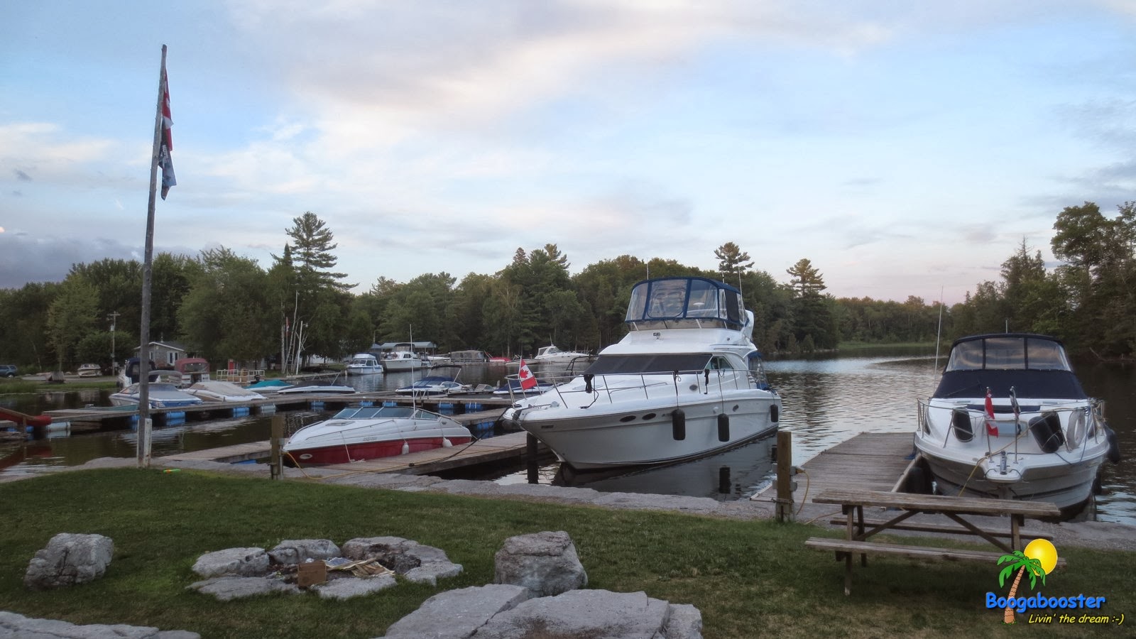
This is Fenelon Falls Marina, a spot we had stayed at in previous years;
Fenelon Falls Marina, on Cameron Lake.


A shot of the recently expanded #boaters tie up wall. The last time we had visited here (6 years prior to this trip), this wall didn't exist and there was precious little areas for boats to tie up to. So, my hat's off to the town and Parks Canada for getting this project completed! A wonderful spot to spend a night or two;

Boaters tie up wall at the upper side of the Fenelon Falls Lock.

Here's a video of our arrival, as well as some masterful docking of 'Boogaboo IV'. Take note of the fellow boater, Mike, who takes our bow line as we approach the tie up wall. I wanted to point out that THIS is the correct way to handle someone's line. I've learned to watch people on the docks when they are 'helping' us in, to make sure they don't pull or cleat us off right away. When the boat is still manoeuvring like this, some slack is needed to bring the back end in, forward or back. More than once I've had to tell the dock attendants to slack off the line, because they end up pulling the front of the boat right tight to the dock. The result? The ass end is 4' off the dock! Thanks again, Mike;


One of the big attractions for many boaters and visitors in general is the close proximity to restaurants and shops, immediately beside the lock. This is located right in the downtown core of this small, but fully serviced village. The only problem is that the Beer Store isn't within walking distance, and there is no taxi service in town. So, be sure to stock up beforehand. There is an LCBO liquor store just a block over, so that's easy.
Restaurants and shopping right beside the lock.

The lock chamber. As the town is busy all season long, there's always a crowd watching the boats coming and going through. This is one of those spots where, when taking the boat through the lock, you feel like a monkey in a cage, with all the gawkers watching your every move;
The lock chamber at Fenelon Falls.


Downtown FF. Well, the old part of town. As with the rest of the small towns, they have their new section on the outskirts for the cluster of big box stores. Pretty soon, every town in Canada & the U.S. will look the same, something I call the homogenization of North America.
Downtown Fenelon Falls.

Anchor Girl looks around at the bottom side of the lock. This used to be a double set of locks, with the indent in the foreground being where the old lock doors opened in to. This was converted to one during the big wave of upgrading projects that took place along the Trent Severn Waterway during the 1960's.
The bottom of the lock.


Ominous looking clouds blew in on the first afternoon, but after a little sprinkle, they cleared out to reveal a beautiful sky.
Scary looking clouds over 'Boogaboo'


The clouds moving out;
Clouds and sun over the railway swing bridge.


Not much more than a pretty rainbow out of the passing rain clouds.
Rainbow over Boogaboo at Fenelon Falls.


Cool pic, eh?
The sun returns to the boats at Fenelon Falls.


 Mike (who helped us in on the first video) & I discuss the deeper meanings of life, like #boating and Bayliners ;-) Did I spell that correctly this time, Mike?

Boats and Bayliners.


This is a collection of rentals at 'Summerland Cottages', located directly across from where we were tied up, close to the swing bridge.
Rental cottages on the Fenelon River.

Here we go, the sunshine returns, the wind dies down and we settled in for a lovely evening. Good times, my friends, good times :-)
Sunshine on the water.

Perry the Penguin, relaxing and enjoying watching the boats going by on our second day here.
Perry the Penguin catching a few rays.

I took Perry over to the welcome sign for some pictures.
Welcome to Fenelon Falls - and they put it in stone!

Perry & I enjoying the glorious setting sun. This place sure has some beautiful sunsets!
Sunshine on my shoulders - and Perry in my cap :-)

Nice.
Pretty sunset.

 Anchor Girl snapped this lovely pic of the setting sun's reflection off the side of the 'Kawartha Spirit' cruise boat.
Kawartha Spirit framing the sun.


One more, spectacular view. Enjoy.
A spectacular setting sun over Cameron Lake.

The best part of this year's holiday voyage is that we got to return here once more. And to make it even better, we got to stay both at the top (like here) and the bottom of the lock. so stay tuned for those upcoming posts, as well!

:-)