First, I made the overall <-- width --> a bit wider to fit in all the words that profusely spew from my keyboard. That, and more importantly, I am now presenting the photos in a B I G G E R format. I've often wondered if you were actually clicking on the photos to see the full size. Well, tonight I discovered a new editor that allows for the larger format photo presentations. You can still click on them for an even larger look, but at least they initially show up a bit better.
Be letting me know what you are thinking of this . . .
Now for some learning stuff. Getting back to the charts, when I was highlighting the day beacons, bifurcation buoys and ranges, I came across a 'wreck' symbol close to the Shawanaga River (the spot we hope to get to this summer). Being the inquisitive kinda guy that I am, I did some digging on the inter-web to see if I could find out something about the wreck.
As a quick aside (since my head is so full of otherwise useless information), there is another wreck that I am aware of - on chart #2202 - at the aptly named 'Wreck Island', which is in the Moon Islands, close to Henry's Restaurant. That one is for the 'Waubuno', a vessel that went down in a storm on November 22, 1879. Hmmm, November 22 on Georgian Bay - any guesses as to what sort of conditions might have precipitated it's premature demise? I did some research on that last year and found a couple of photos of it in it's current condition & was quite surprised to see how much has survived over all these years. . .
What I found about the latest wreck is really cool - that's why I'm sharing it with you. First off, here's a picture I took of the area of the chart that I'm referring to;

On close inspection, you'll notice that the wreck symbol has a port side day beacon indicated right beside it. You may have also noticed that this is all right beside yet another Turning Island / Turning Rocks area! Let's see, there's a Turning Rock at Honey Harbour, another at the Waubaushene Channel, a Turning Island just before the Parry Sound / South Channel cutoff & wherever else I'm sure I've seen that name. Have these people no sense of originality?
I have another very interesting aside (groan) on the subject of place names on Georgian Bay, but I'll spare you on that for this episode and save it for another time - but don't let me forget ;-)
But, alas, I digress. . . . After a bit of creative searching, I was able to not only find pictures of the wreck, but it's name & why the heck the thing is there. Here's a really cool 'current' shot of the wreck that I found;
 |
| Credit: https://www.facebook.com/sskeewatin/ |
Not only is the wreck there, but the day beacon is mounted right on top of it! I'm pretty sure that the white thing that he marker is mounted to is the old steam boiler for the vessel.
I was also able to find out that the vessel was called the Metamora, built in 1864 and found it's way to this spot as a result of a fire, back on July 30th, 1907. It actually served as a gun boat for five years and was, during that time, fitted with armor and cannons! And guess what else? I have a picture of it, taken shortly after it came to rest in this spot;
 |
| Credit: https://www.facebook.com/sskeewatin/ |
Now isn't that cool? How many times do you come across something like this? Well, I want to visit it. As you saw on the charts it's only 30 miles north of Parry Sound - or roughly 170 (!!) miles from home port. Now THAT'S COOL!
~~ At Echo Bay ~~
It just came to mind that our continuing review of the Georgian Bay trip '09 is stuff that is now something that's gonna be referred to as taking place last year. Another year, another decade. Where does the time go?
We'll start this one off with a screen shot from our chartplotter when we arrived at this spot. One hundred and forty + miles from home and a whole other world! Great.
A closer look brings into focus the fact that I had our 'ship icon' set to the circle with the dot in the middle. I've since changed that to an icon of a boat - one that faces in the direction that the real one - Boogaboo - is facing. I did that after our incident of getting turned around in the thick fog. More on that in subsequent postings.

I put this panoramic view of our anchorage from three different photos;

Just after arriving, Sanja was greeted by this stowaway aboard SunAria. You'll hear us talking about it in the next video clip;

A video panning view of our anchorage;
First one in for a swim shower!
Actually, what happened was that I was taking a stern line to shore with the dinghy. I thought I was in only two or three feet of water, so I stepped out to walk the rest of the way in - only to find out that I was in more like EIGHT feet of water. Straight down I went - me, anchor, glasses, cap & all!
Ya, everyone on the big boats thought that was hilarious! That's how I found myself to be first in the water that day;

Why is it that I always seem to find Von A watching me while I am bathing?

The next day was a beautiful one with lots and lots of sunshine! This is looking out from our anchorage, towards the east and where we all go for the first part of our dinghy adventure;

Getting ready to head out on the big ride. Look at the colour of the water! Wow!!
A beautiful still shot of the Three Rays in the sun;

And from a bit farther away;

Echo Bay is actually two distinct bays - the north and the south arms. Our anchorage was in the south arm, as the north part is a little bit tricky to get into with the entrance being very shallow in spots. That said, we did dinghy up to that part on this trip (as you'll see shortly) and found a fair size cruiser anchored in there. As we left that part, they pulled out as well and we all hung back to see what track they followed to leave the north arm.
And we're on our way;
And we're on our way;

As you can see, we journeyed somewhat off the beaten track and straight into a Lilly pad patch. No problem, we just had to go dead slow, as it was a bit shallow in spots. Shallow being rocks close to the surface;

You see, it's not only rocks and trees up here. Sometimes you can run into salad :-)
Looks like this is as far as we can go in this direction;
Looks like this is as far as we can go in this direction;

Mr. Von A surveys the surroundings while the gals enjoy the gorgeous day before we head to the north arm;

Back on our way, we ventured to the northernmost part of Echo Bay to check out a narrow channel marked on the chart;

Man, look at what we found. . . How beautiful is this? C'mon, I'm asking you;

This is looking out the other end of the channel. Look close & you'll see a passing boat, heading north along the Small Craft Route;


Back at the boats after our long adventure, Anchor Girl takes advantage of the warm sun for a swim shower. The oil slick you see on the water was as a result from a little overindulgence in sun tan lotion on the Water Wings vessel. I think that's where it came from, right Bilie Sue?


Here's a simple video look from the back of Boogaboo, taking in the view from the anchorage. You'll hear Von A talking in the background to Ugly Pugsely's babysitter and my comment on how much I DIDN'T miss him on this trip;
Our fun day in the sun was capped off with a dinner at the world famous Henry's Fish Restaurant - the original one on Frying Pan Island, only accessible by water. As SunAria was the only vessel that wasn't anchored or tied to shore, we all piled on and let Sanja take us over;

Our fun day in the sun was capped off with a dinner at the world famous Henry's Fish Restaurant - the original one on Frying Pan Island, only accessible by water. As SunAria was the only vessel that wasn't anchored or tied to shore, we all piled on and let Sanja take us over;

Ah yes, the lovely spot at Henry's. We never got a chance to spend a whole day there this time around, but I'd love to this season. Lots of entertainment here and relaxation all rolled up into one. Plus, you can get a decent fast food meal when you don't want to BBQ :-)


Tell me, what are your impressions of your fist time at Henry's?
Anchor Girl points out the sites to Sanja as we head into the restaurant;

Fish & chips;

A brief dinner vid;
Von A catches a quick after dinner smoke before we get back onto SunAria for the calm, relaxing, peaceful, quiet, easy, flawless, well executed, uneventful trip back to Echo Bay;

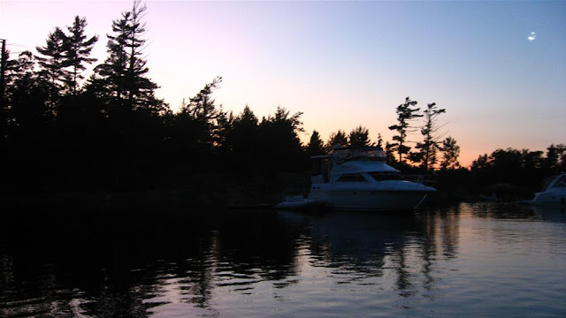
A lovely evening shot;
Here's Tanner & Kevin (and the other fellow who's name escapes me right now), from Parks Ontario to collect our mooring fees for the evening. The deal in the park is that you can anchor anywhere for free, but if your boat is tied to shore, a $10 fee per boat, per day applies.
That was more than acceptable for us, as they took our excessive garbage (and empties) away each time and were a great source of local knowledge. They told us about some other good anchorages, what waters to avoid and even drew lines on my park map showing the otherwise uncharted route into an area called Woods Bay.
Woods Bay was going to be our next voyage of discovery, as it was to be our jumping off point for an all day dinghy ride up to the Moon River Falls. Unfortunately, the park rangers also brought us bad news this night about some tragic drownings at the falls that very day. As a result, the whole area was off limits. So, as seemed to be the case for the whole season, our plans once again changed on the fly;

Let's see, Sanja, looks like you have no less than five charts and maps here under review. With all your new found insights and experience - not to mention the pleasant on water coaching by myself - on Georgian Bay, does that mean you are going to lead us up to Byng Inlet this summer?

This early morning shot was taken on morning #2 at Echo.
Seems someone had a hard time sleeping that night and was up early enough to capture this great sunrise;

. . . . Coming up next, the extended crew of the Maple Leaf shows up for a good, old fashioned sing-along. . . .
Now the seats are all empty, let the roadies take the stage . . .
Anchor Girl points out the sites to Sanja as we head into the restaurant;

Fish & chips;

A brief dinner vid;
Von A catches a quick after dinner smoke before we get back onto SunAria for the calm, relaxing, peaceful, quiet, easy, flawless, well executed, uneventful trip back to Echo Bay;

A lovely evening shot;

Here's Tanner & Kevin (and the other fellow who's name escapes me right now), from Parks Ontario to collect our mooring fees for the evening. The deal in the park is that you can anchor anywhere for free, but if your boat is tied to shore, a $10 fee per boat, per day applies.
That was more than acceptable for us, as they took our excessive garbage (and empties) away each time and were a great source of local knowledge. They told us about some other good anchorages, what waters to avoid and even drew lines on my park map showing the otherwise uncharted route into an area called Woods Bay.
Woods Bay was going to be our next voyage of discovery, as it was to be our jumping off point for an all day dinghy ride up to the Moon River Falls. Unfortunately, the park rangers also brought us bad news this night about some tragic drownings at the falls that very day. As a result, the whole area was off limits. So, as seemed to be the case for the whole season, our plans once again changed on the fly;

Let's see, Sanja, looks like you have no less than five charts and maps here under review. With all your new found insights and experience - not to mention the pleasant on water coaching by myself - on Georgian Bay, does that mean you are going to lead us up to Byng Inlet this summer?

This early morning shot was taken on morning #2 at Echo.
Seems someone had a hard time sleeping that night and was up early enough to capture this great sunrise;

. . . . Coming up next, the extended crew of the Maple Leaf shows up for a good, old fashioned sing-along. . . .
Now the seats are all empty, let the roadies take the stage . . .